


The ECMWF ensemble data are now available globally on WZ up to 15 days ahead for the 00 and 12Z runs and up to 6 days ahead for the 06 and 18Z runs. Also meteograms for the operational runs have been added.
Model output from the Polish meteorological office has now been added. The high resolution AROME (https://bit.ly/33K199R ) model up to 30 hrs ahead and the lower resolution ALARO model up to 60 hrs (https://bit.ly/3nPPey2 ). Thanks to @imgwmeteo for publishing the data.

Many new variables available for UKMO high-res, e.g. the accumulated snow. Higher areas of Europe could see some snow this week. The output is now available 4 times a day instead of 2 (although only up to +60 hrs for 06 and 18Z runs). See here: https://bit.ly/3kXkoCg

First snow of the winter season is possible next week in many parts of Europe. How cold it will get is still uncertain: ECMWF shows one of the colder options at +168 hrs. You can easily compare the different operational runs here: https://bit.ly/3Cq2lL0

The output of the Climate Forecast System (CFS) is now available for 4 months ahead (not to be used for weather forecasting of course )
)

Canadian model GEM was not working for some days but is now back with higher resolution (~15 vs 25 km).

Several new things on WZ this weekend: the UK Met Office output is now available for the EU up to 168 hrs ahead at much higher resolution (~15 vs 250 km). Also new variables 850 hPa & 2m temperature.

A often requested feature was to add ensemble diagrams of the mean sea level pressure: they have now been added here: https://bit.ly/3CNEMx3

Extreme heat forecasted in the west of Canada and US: GFS predicts temperatures of 39 deg. C in Vancouver on monday! Also in Europe generally above normal temperatures for the coming week.


But the next 5 days some completely different weather with an Arctic air outbreak with 850hPa temperatures below -10°C over the UK and in many places also snow: https://bit.ly/2PiRksq


Extremely warm March day yesterday: temperatures of >25°C in parts of FR, DE, NL. In NL the all-time March temperature record from 1968 was broken as it became 26.1°C in Arcen, see here https://bit.ly/3fKe7rZ and here https://bit.ly/3fKe1R9


The new IFS parallel run from the 47r2 cycle is now available at WZ: https://bit.ly/3s8lo7N . It will become the new operational run 11 May. More about the new features in the model here: https://bit.ly/3dzpYb0 . OP and PARA agree that next week will be extremely mild in Europe.

The COSMO model has been discontinued by the DWD and will be replaced by the ICON D2 model also on wetterzentrale: https://bit.ly/3tPAqRv . ICON-D2 performes generally better than COSMO: https://bit.ly/3aVlh8G . It is available 8 times daily up to 27 hrs ahead (03Z up to 45 hrs)

Cold air from Scandinavia moving southwards and an activating band of snow is stalling over Germany and the Netherlands and will stay there for the next 24 hours. Follow temperatures here: https://bit.ly/39W82VT and the precipitation radar here: https://bit.ly/2LqDJ01
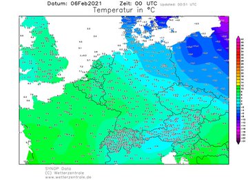
Warm air masses from the Sahara and cold air from Scandinavia collide and will bring storm 'Darcy' to a standstill over the Benelux and middle Germany with 10-30 cm snow and strong winds: https://bit.ly/3pXX1c3
Both ECMWF and GFS now predict spectacular amounts of snow (>30 cm) for northern NL and DE. Also frozen rain and snowdrifts are possible su/mo in this area. You can explore multiple model charts at once here: https://bit.ly/3tmN6ir

Large contrasts between warm and cold over Europe during the next days. Scandinavia remains cold; middle Europe could also get a new cold period, but uncertainty remains high with temp. diff. of 20 degrees at 850hPa from N to S Germany in the GFS 06Z Ens.: https://bit.ly/2L3ED2j

Very cold morning in Scandinavia with parts of Sweden reporting temperatures below -30 deg. C. An updated station list has been used for temperature reporting, increasing the number of observations available worldwide from now on: https://bit.ly/2XVYZgK

The meteogram of the GFS parallel run has been added on the website. Both operational and parallel are now available up to 15 instead of 10 days ahead. See e.g here: https://bit.ly/35tIw7H . The GFS ensemble shows that a cold and snowy episode is possible in parts of Europe.


Es gibt keine weiteren Tweets in dieser Timeline.
